
Walk a Kalamazoo Township Street by Address
Start a Kalamazoo Township street directory search with the county parcel record, not with a guess about who occupies a home. The parcel result supplies the property address, parcel identifier, owner association, and local-unit context available from the county. For Kalamazoo Township parcels, save the situs address exactly as shown. A situs address is the physical place attached to the parcel. An owner mailing address is where tax material goes, and it may be a post-office box, agent, or another residence. The two fields should never be substituted for one another.
- Open the Kalamazoo County Parcel Search and use the Street route. A street name returns matching parcels; when spelling is uncertain, the county advises trying the number alone.
- Record the exact address, parcel ID, listed owner, and township or other local unit. Check the parcel on the county map before assuming a Kalamazoo postal address is in the township.
- Use the Kalamazoo County Parcel Viewer to select the parcel and the adjoining polygons. The map is useful for geometry and jurisdiction, while ownership needs confirmation in assessor and deed material.
- Take the owner name or parcel ID to the County Deeds Search. Match the legal description before treating a recorded instrument as part of the same property trail.
- For a dated household clue, consult the Kalamazoo Public Library criss-cross and directory material. Those sources can show a historical listing at a number, not a guarantee of present occupancy.
That sequence keeps a Kalamazoo Township street-by-street search tied to a real parcel. It also prevents a common error: reading an owner, a registered voter, a permit applicant, or an old telephone listing as the same kind of evidence.
Kalamazoo Township Street Directory Search Fields
The county’s public Parcel Search has three routes, Owner, Parcel ID, and Street. For this Kalamazoo Township street directory, the Street route is the entry point because it accepts any portion of a street address. The owner route accepts a partial name in LastName FirstName MiddleInitial form. Kalamazoo Township parcel IDs may be entered with hyphens, spaces, or no punctuation, and a prefix can browse a group. The county calls its data a general annual source and directs users to the local assessor for the most current building detail.
| County field | Input | Required | Useful street-search detail |
|---|---|---|---|
| Owner | Text | No | Partial LastName FirstName MiddleInitial entries are accepted. |
| Parcel ID | Text | No | Use a full key or prefix, with hyphens, spaces, or no punctuation. |
| Street | Text | No | A street name can return the whole street; try the number alone when spelling is uncertain. |
| Search By | Tabs | Choose one route | Select Owner, Parcel ID, or Street before reviewing the result list. |
Kalamazoo Charter Township Assessing can answer local assessment questions at 1720 Riverview Drive, by email at assessor@ktwp.org, or at 269-381-8083 ext. 118. County Equalization is the broader public search starting point for Kalamazoo Township. A Kalamazoo Township card may show a property address, parcel number, assessed value, taxable value, and jurisdiction, but the accessible county page does not promise every live-card field. Label only what the record actually displays.
Kalamazoo Township Records Linked to Streets
A street name is only the first link. Each Kalamazoo Township record set answers a narrower question, and the parcel identifier connects the strongest sources. The county GIS viewer helps place a Kalamazoo Township parcel on the block. The Register of Deeds supplies recorded instruments. KABA may hold work records by location. A properly scoped Kalamazoo Township election-record request has a different purpose and carries redactions. Use the evidence for the role it actually documents.
| Address-linked record | Custodian | What it can establish | How to reach it |
|---|---|---|---|
| Parcel assessment | County Equalization and township assessor | Parcel ID, property address, owner association, assessed and taxable values | Free county search; local assessor for current detail |
| Parcel map | Kalamazoo County GIS | Boundary, road position, adjacent parcels, and local-unit layers | Free ArcGIS viewer with a source-data warning |
| Recorded land index | County Clerk/Register of Deeds | Grantor, grantee, document type, date, parcel when indexed, and legal description | Free index; paid images or counter workstations |
| Permit file | Kalamazoo Area Building Authority | Address-linked work, dates, and released application details | Forms and written request; no public address index found |
| Historical criss-cross entry | Kalamazoo Public Library | Past address-to-name or telephone listing evidence | Library paper and microfiche collections |
Michigan’s Qualified Voter File can include public registration fields in a lawful request, but the personal Michigan Voter Information Center is designed for an individual’s own record, not an open Kalamazoo Township street browser. A Kalamazoo Township street or block request must be scoped through the state QVF process or the appropriate custodian. Public production withholds sensitive fields, and voter history records participation rather than ballot choices.
Map a Kalamazoo Township Street Segment
The county viewer gives a practical way to inspect a Kalamazoo Township street segment without estimating from a basemap. Search an address or parcel, select its polygon, note the parcel ID and jurisdiction, then turn on road, address-label, and local-unit layers as needed. Click each adjoining Kalamazoo Township polygon instead of assuming that lots which look adjacent have the same tax boundary. Roads, drainage features, condominium parcels, and legal descriptions can break a visual pattern.
The GIS page says its maps and documents compile information from township, city, county, state, and federal sources and may contain errors. Treat the viewer as a Kalamazoo Township navigation and boundary tool. Then open the assessor record and the recorded document for names and legal details. A map layer showing zoning, flood, drainage, or district context is not proof of ownership or current presence.
- Parcel
- A county land-record key for a particular tax parcel. It links map work to assessment and deed research.
- Situs address
- The physical property address. It is distinct from the tax mailing destination.
- Plat
- A recorded map that can identify a subdivision, lot, block, or other legal layout.
- Criss-cross directory
- A reverse-style directory arranged to help move from an address or street number toward a historical listing.
Follow Deeds Along a Kalamazoo Township Street
Recorded documents are not reliably address-searchable because an address is not required on the instrument. The Register of Deeds recommends name-first work. After locating a Kalamazoo Township parcel, search the current owner and parcel number, then compare the legal description, subdivision lot and block, or metes-and-bounds wording. A grantor is the party transferring an interest. A grantee is the party receiving it. Matching those roles and the legal description is safer than matching a Kalamazoo Township street name alone.
The county reports land-record images back to 1831, with complete indexing through 1984. The online index is free. Images cost $1 per page plus a $2.50 technology fee through the document-search system. The public workstation at the County Administration Building supports Kalamazoo Township grantor/grantee research and charges $1 per printed page. The office can locate the latest deed for $5 per property, then $1 per page, and certification adds $5. County staff do not perform in-depth title searches or offer legal advice.
The county deed-index interface is the source shown in the following image. Its name, date-range, liber/page, document-number, and parcel-number routes support a parcel-led search after the street result is narrowed.
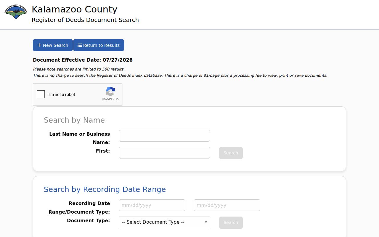
Use the screen as a Kalamazoo Township index entry point, then verify the instrument against its parcel and legal description. The available image layer should not be read as a claim that every older name is completely indexed.
Kalamazoo Township Address Permits and Planning
The Kalamazoo Area Building Authority handles building permits and inspections for Kalamazoo Township. Its files can provide a dated Kalamazoo Township building-history clue, such as a permit number, work category, issued date, inspection event, final status, or released applicant and contractor information. They document a transaction with the building authority, not a list of household members. No searchable public address index was located, so the useful fallback is a focused request with the property address, parcel number, approximate date, and record category.
KABA’s permit page provides building, demolition, electrical, mechanical, and plumbing applications as well as a Freedom of Information Act form. Kalamazoo Township planning and zoning files can add site-plan or zoning context through the township department or a written request. The township permit route should be used for township property, rather than presuming a City of Kalamazoo department is the custodian.
Note: Permit dates can help place a physical change in time, but they do not identify everyone connected with the address.
Bridge Old Kalamazoo Township Street Names
Historic Kalamazoo Township address work needs a second pass. Kalamazoo city adopted a central-point numbering system in 1883 and changed numbering citywide in 1925. There was no 1925 directory, so compare the 1924 and 1926 volumes. The 1932 Sanborn atlas includes old and new numbers. A Kalamazoo Township address near the old city edge may also be affected by annexation history, even when a present postal label still says Kalamazoo.
Kalamazoo Public Library records several name changes, including Cork and St. James, Oakland Drive and Asylum Avenue, Riverview and Seminary, Vine and Rice, and portions of Westnedge, West Street, and College. Its criss-cross research note also warns that Miller Road becomes ML Avenue outside the City of Kalamazoo. Search both names for a Kalamazoo Township address, confirm the current jurisdiction in GIS, and use a plat or deed description to bridge the address. The historical volumes themselves are described in the Kalamazoo Township city directories collection.
Kalamazoo Township Street Record Fallbacks
When a web result stops short, use the channel that holds the missing layer. The County Administration Building at 201 W. Kalamazoo Avenue has public land-record workstations. Deeds Search lists hours as 8 a.m. to 4:30 p.m. Monday, Tuesday, Thursday, and Friday, and 9 a.m. to 4:30 p.m. Wednesday. Older images and partial indexes may require the workstation, deed books, or archival research rather than another broad online query.
Kalamazoo Public Library’s Local History Collection is at 315 S. Rose Street, second floor. It holds directories, telephone books, maps, atlases, Gazette microfilm, and local history files; its listed hours are Monday through Thursday 9 a.m. to 8 p.m., Friday 9 a.m. to 6 p.m., Saturday 10 a.m. to 5 p.m., and Sunday 1 p.m. to 5 p.m. The library number is 269-553-7808. Its paper and microfiche material is especially useful when an older Kalamazoo Township street number has changed.
County digitization expanded Kalamazoo Township access in 2024, when an ARPA-funded project scanned more than 1.5 million land documents and index books dating to 1831. That improvement does not erase the difference between an available image and a complete name index. Preserve the source, date, and search terms for every Kalamazoo Township street-directory result.
Limits of a Kalamazoo Township Street Directory
Kalamazoo Township public address records are not a roster of every person on a block. The assessor generally associates an owner with a parcel, while a mailing address may point somewhere else. A historical directory can contain an old listing. Utility accounts and motor-vehicle residential addresses are not public Kalamazoo Township street-search sources. Michigan election files protect sensitive data, Address Confidentiality Program participants can use substitute addresses, and sealed material remains unavailable. State records should be read as dated evidence with a defined scope.
Lawful use. Kalamazoo Township address records support personal, historical, property, and civic research. They do not authorize repeated unwanted contact, stalking, harassment, or intimidation; Michigan’s anti-stalking law includes MCL 750.411h.
Correct a Kalamazoo Township error with the office that keeps the record. For a county public-record request, the Kalamazoo County FOIA portal accepts a focused written request. Michigan FOIA ordinarily calls for a response within five business days, with one written ten-business-day extension allowed. A narrow Kalamazoo Township address, parcel, date range, and record type help the custodian locate existing records.